Week in Review:
April 7-13
Monday, April 7th
PM—11.5
Miles—1:48—1,900’—Angels Landing, Emerald Pools, Zion Canyon Road (Zion
National Park)
Less than an hour after finishing the eight-hour drive from
Telluride and gorging myself on a $5 Pizza Hut lunch buffet I decided it was a
good idea to run up Angels Landing. The entire way up I was on the verge of
throwing up, but I kept running until I hit the beginning of the easy scramble
up to Angels Landing. From here on, I moved up at a steady pace. I stopped my
watch at a collection of cairns near the far edge of the landing (this is
actually lower than the true summit) in 30:32. I descended the landing quickly
before falling into a relaxed pace on the steep, sharp, and paved switchbacked
trail descent. I reached the trailhead with a roundtrip time of 51’ish minutes
I think. From there, I headed over to the Emerald Pools, stopping to take lots
of photos along the way. After the pools I rejoined the Zion Canyon scenic
drive for about four miles of pounding the pavement at low-6 minute pace.
 |
| The view from Angels Landing is well worth the effort |
 |
| Upper Emerald Pool |
Tuesday, April 8th
AM—8.5
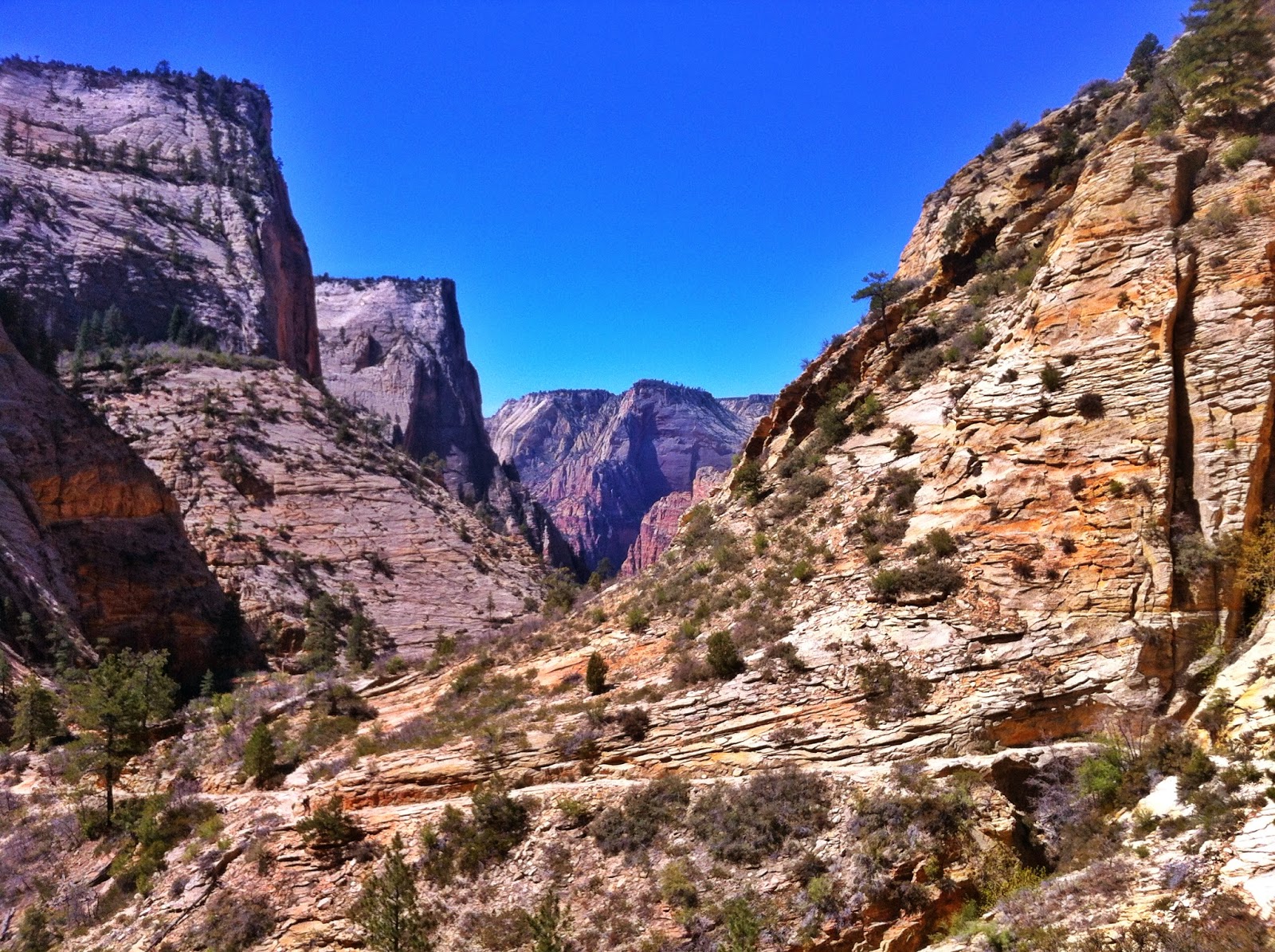
Miles—1:41—2,400’—Observation Point and Hidden Canyon (Zion)
This is a fun, challenging run that’s 100% runnable. The
ascent gets steep in a few places, but for short enough durations that you can
just grit your teeth and grind it out knowing there’s relief not too far off. I
reached the Observation Point in about 48 minutes. Not bad for a 2,400’ climb
over four miles on tired legs. On the way down I noticed a horrible pain in
both feet near my big toe. I was wearing a pair of 1010’s that I fixed with
some ShoeGu. Apparently when the glue dried it formed hard, sharp objects that
were causing blisters fast. This almost brought me to a crawl for a while.
Running was not an option considering that each step of the pounding descent
dug these sharp blister causers deeper into my feet. I stopped a hiker and
asked for some tape. He didn’t have any, but he did have a sharp pocket knife
that I used to cut out the glued portion of my shoe upper completely off. The
relief was instantaneous—I could run again. On my way down I took a short
detour to the Hidden Canyon. This was a shit show of tourons (tourist + moron =
touron) who were scared to death of the minimal exposure encountered on this
trail. Running wasn’t even an option. So I walked in frustration until I made
it back to the main East Rim trail where I cruised the remaining switchbacks
back to the parking lot.
 |
| Looking back as I head up Observation Point |
 |
| The views from Observation Point are also worth the effort. Looking down Zion Canyon with Angels Landing in the middle. |
 |
| Another view down Zion Canyon from Observation Point |
 |
| Descending from Observation Point |
 |
| A much needed shoe surgery. |
 |
| Another view coming down from Observation Point |
PM—5 Miles—0:52—1,500’—Angels
Landing (Zion)
My legs felt sluggish from the start. So, I decided to start
off easy, be patient, and just see what happened. The trail starts off flat as
it follows along the riverbed, but then it gets vertical pretty fast. I ran
along at 7:30 pace for the flat part before I got into low gear and began
grinding up the switchbacks. After crossing the bridge I was able to push the
pace again on the reasonable flat stretch of trail before leading up to the
Walter’s Wiggles switchbacks. Once again, I fell into a power hike here. It’s
hard to justify the extra energy expenditure required to run these when the
scrambling section is right around the corner. During the scramble I kept
thinking about how slow it felt like I was going. Somehow, as I neared the top
I was flirting with being able to break 30 minutes for the ascent. So I picked
up the pace for the runnable section near the top and reached the collection of
cairns in 29:55. My legs were a little shaky so I just coasted on the descent.
 |
| Descending the "exposed" and "terrifying" Angels Landing |
Wednesday, April 9th
AM—14
Miles—3:18—1,700’—Kolob Arch (Zion)
Nice and easy run on pretty tired legs. This was an
incredibly scenic portion of the Trans Zion route that Ben and I missed out on
in early March. On the outward leg the first five miles or so were pretty
cruiser, with the first mile or two being a significant descent. The last two miles
to Kolob Arch were mostly in a sandy riverbed, which sort of sucked since I was
wearing my newly modified 1010’s (see photo above). I sat on a downed tree for
30 minutes or so, staring up at the arch, while enjoying a Cliff Bar that some
hiker absolutely insisted I take from her. I wasn’t really in any hurry to
tackle the two miles of sand again. After walking through most of the sand I
finally hit the runnable stretches again. By this time the sun was out in full
force and the water in my handheld was almost non-existent. Oh well, looks like
the making of a nice little bonk. It ended up being exactly that. I was able to
run the flats, but any uphill (no matter the grade) was not happening. Finally,
on the last half-mile of ascent to the trailhead I was able to run again. I
guess a gallon of cold water back in the Taco was all the motivation I needed?
 |
| Running along a sandy riverbed to the Kolob Arch |
 |
| Dam on Lake Powell |
Thursday, April 10th
AM—15
Miles—3:01—4,600’—South Kaibab Trail (Grand Canyon National Park)
Overall, I took the descent pretty mellow. There were some fast
spots, there were some super slow spots, but overall it was mellow. I stopped
to take quite a few photos along the way as well. I didn’t really know if I
would end up down at the river since my legs felt especially awful and I was
also breaking in a brand-new pair of shoes. However, the farther down I went
the better my legs and the shoes felt. So, I just kept going and next thing I
knew I was crossing the Colorado River to Bright Angel Campground for a water
break. I reached BA Campground in a comfortable 1:12, which includes the ~5
minutes it took me to cover the 0.6 miles from where I parked the Taco to the
trailhead. After a ten minute bathroom and water break at BA I turned around to
begin the arduous ascent—all 4,600 feet of it. I was cruising along pretty
comfortably up to Skeleton Point before the constant uphill began to take its
toll on me physically and mentally. Just below Skeleton Point I passed a couple
hiking down. They asked if I would stop and take a photo with them. After
asking if they were serious I told them I wasn’t going to stop in the middle of
running up a 5k feet ascent, but they were welcome to run alongside me to take
a photo if they wanted. They didn’t take me up on my offer. Somewhere above
Skeleton Point I reached a steep section that finally reduced me to a power
hike. From here on, the rest of the ascent was a mix of about 80% running and 20%
power hiking up to the trailhead. The last series of switchbacks sucked per
usual, but with a little gritting of teeth and grunting I was at the top before
I knew it. After sitting around for 10-15 minutes to catch my breath I got up
to finish the last 0.6 mile to the Taco. The heat today removed any thoughts of
running R2R2R tomorrow from my mind.
 |
| Sunrise on my drive to the Grand Canyon |


 |
| When you're at the bottom of the Grand Canyon there's only one direction to go...Up! |
PM—2.5
Miles—0:58—200’—Hike to Shoshone Point with Alan (Grand Canyon)
Alan wanted to get out and walk a little after driving 3+
hours. So I suggested we head out to Shoshone Point since I hadn’t been there
yet. It turned out to be a great viewpoint with relatively little traffic
compared to other parts of the Canyon.


Friday, April 11th
AM—20 Miles—3:54—4,800’—South Kaibab, Bright Angel, Rim Trail Loop
(Grand Canyon)
This is the third time I’ve
done this loop. It’s quickly becoming one of my favorite runs in the Grand
Canyon. The only negative aspect of this run is that you hit two busy sections
near each trailhead, you will almost certainly run into multiple mule/horse
trains, and the Rim Trail is the very definition of a tourist shit show. I
began my descent of South Kaibab at a good pace. I pushed the pace when the
trail was straighter/smoother than average and slowed in the more technical
areas. I’ve never actually descended the south rim recklessly or with any
intention of a speed descent. As I closed in on the Colorado River I came upon
a ridiculously long mule train. I had to walk behind the goddamned thing for a
half-mile and almost 10 minutes—breathing in the pulverized dust they kicked up
the entire time. When the wranglers finally let me pass I sped off in an effort
to make up lost time. Just before reaching the river I was treated to a train
of horses plodding along with tourists who seemed healthy enough to walk down
the trail on their own two feet, but were on horses nonetheless. Fortunately, I
was able to cross the bridge before them and reached the river in 0:58. Just
after crossing the bridge there was ANOTHER train of horses with tourists on
their backs. Ughh…I snagged some water at Bright Angel campground before
hitting the Bright Angel trail to grind out the nearly 5k feet of ascent back
to the South Rim. I hit the second river crossing in 1:04 and began the climb
out. I was grinding along pretty effortlessly, occasionally fielding the
questions from hikers who had seen me on South Kaibab yesterday. Eventually, I
saw four beautiful women running down the trail towards me—it wasn’t that hot
out so I didn’t think I should be hallucinating. Turned out to be Darcy,
Krissy, and others. I knew they were running R2R2R, but expected them to use
the South Kaibab trail for their descent. I stopped and chatted with them for a
few minutes before parting ways. After a water stop at Indian Garden campground
I began the last 4.5 miles up to the rim—the steep (fun) stuff. It’s a bit
surprising just how runnable the Bright Angel trail is. Yes, it’s steep in
places, but the steep grades don’t last for long. I reached the Bright Angel
trailhead at the top of the south rim in 3:01 from the South Kaibab trailhead.
I was hoping to sneak in under 3 hours, but given that the weather was 15
degrees hotter than average and my legs were fatigued I’m pleased. I still had
four miles of pavement to get back to the Taco. I chose to use the interior
park trails that are away from the rim in an effort to avoid people. I walked
some parts of this since I was dehydrated and starting to get a little dizzy,
but in 41 minutes I was back at the Taco guzzling water. Great day in a grand
place.
PM—4.5 Miles—1:45—1,150’—Hike to 1.5 Mile Rest House (Grand Canyon)
Alan was out running a
R2R2R. So, I decided to head down a little bit to meet him on his way up. My
hips felt like hell and my right foot felt like it was severely bruised. This
limited my walking pretty significantly. I waited for Alan at the 1.5 Mile Rest
House until about 45 minutes before darkness would settle in. At this point, I
decided to head up since I didn’t’ want to stumble around in the dark with a
bum foot. I spent a few hours near the Bright Angel trailhead waiting on Alan
before leaving a note on his car and going to the Taco for a nap. Right as I
began drifting to sleep I was startled by a pounding on my driver’s side
window. I was relieved to see Alan standing there looking a little haggard. I
joined him in his rental car to hear all about his R2R2R before parting ways.
With almost all of the North Rim water sources off, it sure sounded like a
brutal day out there…


AM—5 Miles—1:36—800’—Point
Lookout, Knife Edge, and Spruce Tree House (Mesa Verde National Park)
Both of my hips and my right foot were pretty trashed. So, I
stopped in Mesa Verde for an easy run/jog to try loosening them up a bit. Not
entirely sure if it worked.


Sunday, April 13th
AM—6.5
Miles—1:18—1.900’—Hogsback x2 (Durango, CO)
My friend Michele and her roommate Beau were kind enough to
let me crash on their futon Saturday night. It was certainly nice to have a
shower and relax after beating my body up the past week. I woke up a little
stiff this morning because I’m not in college any more and apparently that’s
the age cutoff for being able to sleep on a futon comfortably. I eventually
loosened up and decided I would go see what the Hogsback was all about. I
decided to take Beau’s dog, Kio, out with me for the first lap. As expected, my
hips and calves felt like hell, but they loosened up quite a bit in the quarter
mile run to the trailhead. There were trails zig-zagging everywhere so I just
followed my instincts and kept going up. On the first lap I hit the summit in
21’ish minutes and completed the lap in 0:43. On the second lap I hit the
summit in 21’ish minutes and completed the lap in 0:34. Not a bad day out
considering how bad everything felt in the morning.
Weekly Totals
Miles—93
Time— 20 hours 15
minutes
Elevation Gain— 20,950
feet
Monday, April 14th
AM—6 Miles—1:09—950’—Fowler
and Eldorado Canyon
David and I decided to try running the Eldorado
Canyon-Walker Ranch lollipop loop. However, almost a foot of fresh snow made us
rethink this decision. We turned around a short while up the Eldorado Canyon
trail and retreated back to the car with the intent of hitting the climbing gym
later.
PM—Climbing Gym with
David
I almost forgot how bad I suck at sport climbing. Almost…Fortunately,
they had a crack at the gym that I could shimmy up easily. That made me feel
worth something…
Tuesday, April 15th
AM—3.5 Miles—1:23—1,050—Partial
2nd Flatiron and Access Loop
I made it about 2/3 of the way up before almost getting
knocked in the head by a chunk of falling ice. So I bailed off the side and
finished a loop on the access trails before calling it a day.
Wednesday, April 16th
PM—3 Miles—0:26—0’—Orrick
Roads
I had to shakeout the legs after the always horrendous drive
through Kansas.
Thursday, April 17th
PM—4 Miles—0:24—0’—Orrick
Roads
Trying to work the kinks out of my legs after all of the driving
in the last week. My legs felt heavy and the pace felt slow. So, I was
surprised to see that I hovered around 6 minute pace for this run.
Friday, April 18th
AM—2 Miles—0:16—0’—Orrick Roads
Easy run to keep the legs
moving.
Saturday, April 19th
AM—62 Miles—11:18—4,000’—Free
State 100k (Lawrence, KS)
Hot and humid. Fell apart on the last lap, but held on for 2nd
place. I may or may not write a little something about this eventually…

Sunday, April 20th
PM—3 Miles—0:35—0’—Orrick
Roads
Ugh…This felt like death…
Weekly Totals
Miles—84
Time— 15 hours 32
minutes
Elevation Gain— 6,000
feet
Week in Review: April
21-27
Monday, April 21st
AM—2 Miles—0:21—0’—Orrick
Roads
Legs still felt like crap, but I was able to shuffle a
little bit faster today.
Tuesday, April 22nd
PM—2 Miles—0:18—0’—Orrick
Roads
Legs felt a little better. Ran a little faster…
Wednesday, April 23rd
PM—4.5 Miles—0:56—350’—Stocksdale
Park Trails
I thought my legs were feeling considerable better until I
hit the first uphill section. Then I realized I have zero drive in my legs
right now. I still puttered along for a little bit before calling it a day.
Felt nice to get off the roads of Orrick.
Thursday, April 24th
AM—8 Miles—1:03—0’—Orrick
Roads
My legs finally felt pretty decent today. So, I tried a
moderate paced run and they responded OK. The first four miles were into a
headwind and about 15-30 seconds/mile slower than the last four miles. It was a
fun little run in the rain.
Friday, April 25th
PM—6.5 Miles—0:45—0’—Orrick Roads
I spent almost all day doing
some extreme cleaning on the Taco. I decided to sneak in a quick run before my
brother got to the house for a family dinner. This was a little loop around the
farmland surrounding Orrick and ended up being a little over 6.5 miles. There
were two railroad crossings that gain 10 feet or less, but that was enough to
remind me how little drive my legs have on the uphills right now. Overall, I
was pleased. I averaged sub-7 pace for the run less than a week after a 100k.
Saturday, April 26th
AM—5 Miles—1:05—400’—Stocksdale
Park Trails
Another slow going day on the trails. The uphills still
drain the life out of me. I tried to open up my pace on a flat, straight
section of trail to see what pace felt uncomfortable. I managed to hit about
9:15 pace before it felt like I was using all of my effort. I would typically
run this around 6 minute pace or less. Still have some healing to do.
Sunday, April 27th
PM—2 Miles—0:15—0’—Orrick
Roads
A really easy day in hopes of having some extra energy in my
legs when I arrive in Boulder tomorrow.
Weekly Totals
Miles—30
Time— 4 hours 46
minutes
Elevation Gain— 750 feet