High in Colorado

High in Colorado
Photo: Mandy Lea Photo

Monday, February 24, 2014

February 3-23—Trying to get Fast(er)


Week in Review: February 17-23
Monday, February 17th
AM—20 Miles—2:44—1,700’—Last Dollar Road
Started off with a slow 1.75 miles on the icy River Trail before picking up the pace a little on the paved bike path. The paved miles on the ascent to the airport seemed to pass by effortlessly until next thing I knew I was descending the dirt road to Deep Creek. My effort on this run felt considerably easier than last week’s 15 miler, but my split to Deep Creek (~7.5 miles) was only 3 minutes slower today. Shortly after Deep Creek I ditched my shirt since I was sweating my ass off in the nearly 50 degree temps. I cruised the next 2.5 miles of muddy, wet dirt road before turning around to head back. My time at the turnaround was 1:24. The climb out of Deep Creek back to the paved road seemed easier than usual, but my split was the same as the last few times I’ve ran it. Back on the pavement I ran a couple of 6:15 minute miles to reach the flat’ish bike path. Here I settled into some 7:15-7:30 miles before slowing considerably on the last 1.75 miles of the icy River Trail for a four-minute negative split. I’m starting to enjoy these longer outings where I run every step of the way. 

Tuesday, February 18th
PM—7 Miles—1:07—750’—Mill Creek Road
Hungover run that I basically put off until the end of the day. I felt surprisingly good once I got started and even debated running a little longer. But I decided an easy seven would be enough for the day. Ran on the River Trail to Mill Creek and on the bike path back to town. 

Wednesday, February 19th
AM—9 Miles—1:35—1,350’—Mill Creek Road (x2)
I still felt crappy today. So I decided to make an early morning run to Montrose for some cheap groceries (Telluride prices are just plain ridiculous) before doing any running. The River Trail was an icy deathtrap after the last few days of freezing-and-thawing. The climb up Mill Creek seemed to take everything I had. I even stopped to hike in a few places on both trips up. About a quarter-mile from the end of the road there were at least two coyotes tearing at the carcass of something. I didn’t really want to be dessert so I turned around at this point on both laps. Slow going on the ice back home. 

Thursday, February 20th
AM—11 Miles—1:37—850’—Last Dollar Road
The first four miles or so were a little cold—around 10F with a wind chill of -5F or so. It didn’t take long for the icebeard to form. I kept the effort mellow all day long since I’ve never really had good luck with trying to run hard in the bitter cold. I always end up pulling or tearing something. So, I ran 8-minute miles on the flat bike path to Last Dollar Road where I ran 10-11 minute miles for the ~800-feet ascent over two miles. About halfway up the climb I started to heat up. I ran about 8:30 pace for the descent versus my typical 6-6:15 pace. The last three miles of bike path back to the house had me sweating pretty good—it had warmed up to a balmy 15F with a 5F wind chill. Beautiful day outside. 

Friday, February 21st
AM—21 Miles—3:05—2,250’—Last Dollar Road
Pretty much the same run as Monday except that I skipped the River Trail (started directly on the bike path), went out 1-2 miles longer on Last Dollar Road for an extra climb, and ran a lot slower. This run seemed to take a little more effort than Monday. Possibly due to the muddy, snowy, and slushy conditions on the road? I started getting some slight pain in my left hip around mile 13/14, but nothing too serious. 

Saturday, February 22nd
AM—7 Miles—1:06—800’—Mill Creek R0ad
Easy day on the bike path and Mill Creek Road. Saw the skull of whatever it was the coyotes were picking on the other day. Beautiful views of Wilson off in the distance. 

Sunday, February 23rd
PM—6 Miles—0:44—250’—Bike Path
I originally planned on an easy ten miles to the airport and back, but decided to take off at a quick pace and just stuck with it. The first half-mile or so was on icy roads/sidewalks in town. So, I held an 8:30-9 minute pace. Once I got on the ice-free bike path I opened up my pace a little and started hitting 6:15-6:30 pace until the three-mile turnaround point at 20:43. On the way back I stopped to talk to a guy pushing a stroller for 3.5 minutes, but didn’t stop my watch. So, my roundtrip time should have been closer to 40 minutes. I didn’t really care since I relaxed the effort back to about 7:15 pace for the return trip. 


Miles—81
Time— 12 hours 00 minutes
Elevation Gain— 7,950 feet


Week in Review: February 10-16
Monday, February 10th
AM—10 Miles—1:26—700’—Last Dollar Road
Easy run on the River Trail and Bike Path before heading up Last Dollar Road about 1.5 miles. This is a fun little hill that I might start using for repeats. I don’t really like the idea of hill repeats, but it may be the only way to get vertical. At least this hill provides the option for a two-mile continuous climb versus some dinky little quarter-mile climb. 

Tuesday, February 11th
PM—8 Miles—1:25—1,200’—River Trail, Boomerang Road, and Mountain Village Golf Course
My legs are going crazy with all of this flat running. So I sought out some vertical—any vertical. After cruising, the River Trail I headed up Boomerang with a mix of primarily hiking and a little running. The snow is still super soft. I just started heading up the paved roads of Mountain Village for a while to get a little more uphill action. Before descending Boomerang I ran some of the “hills” on the groomed golf course trails. 

Wednesday, February 12th
AM—5 Miles—0:46—650’—Last Dollar Road
Parked at the airport after dropping off Ben. I ended up running from the airport, down to Deep Creek, and back. The climb up from Deep Creek was pretty fun; runnable, but enough of a grunt to make you feel like you worked a little. 

Thursday, February 13th
AM—15 Miles—2:00—1,250’—Last Dollar Road
I headed out this morning with the intent of a 15-20 mile run. After a nice warm up on the River Trail I started trying to pick up the pace a little on the bike path; holding a 6:45-7:15 pace. With an easy effort I disposed of the initial two-mile, 500+ feet climb up Last Dollar Road in 0:18. The descent to Deep Creek seemed to take a bit of work just to hold a 6:30 pace. Eventually, I saw the footprints I was leaving and realized the dirt road was pretty muddy/tacky. I hit Deep Creek around mile 7.5 and took that as a sign that I should just run 15 miles today. So I headed back up the 1.5 miles and 450 feet I just descended; reaching the top in 0:13. I cruised the paved road from the airport back to the bike path (with the exception of the last half-mile where I held a sub-5:30 pace). This two-mile stretch took about 0:13. While running back on the bike path all I really wanted to do was walk, but I kept running through the boredom in an effort to make the pavement end as quickly as possible. Back on the River Trail the only thing on my mind was sneaking back in less than two hours. So close. This was the first time in a LONG time that I’ve actually ran 15 miles without stopping or power hiking. I ran even splits for the out-and-back;  one hour out, one hour back. 

Friday, February 14th
AM—10 Miles—2:01—1,900’—St. Sophia Gondola Station from Telluride
I kept the effort easy all day since there was a little tightness in my legs from yesterday. The River Trail was a pretty solid sheet of ice, which helped keep me around 8:30 pace. When I hit Boomerang Road I was pleased to find the snow had finally consolidated quite nicely. So I trotted up the hill with a few stretches of walking. After running on the Mountain Village roads for a mile or so I noticed a snow packed area that looked like a trail. It was unmarked, but I decided to head up to explore. This ended up being the Ridge Trail, which led all the way to the St. Sophia Gondola Station at 10,500+ feet. I was pretty happy to finally find a little bit of vertical (though not much). Took the return trip pretty easy. 

Saturday, February 15th
AM—7 Miles—1:08—750’—Mill Creek Road
Easy jog along the River Trail before trotting up the icy, slushy Mill Creek Road. Easy effort up and down. 

PM—4 Miles—0:53—1,000’—Ridge Trail
Parked at the Mountain Village gondola station and started running up the snowy Ridge Trail at an easy effort. The intent was to meet up with Basit somewhere along the trail and share a few miles with him. We finally ran into each other near the St Sophia gondola station at 10,500’ish feet. After spending a few minutes looking around for more vertical we decided to just cruise down the Ridge Trail. Fun, shirtless run!

Sunday, February 16th
AM—5 Miles—0:47—750’—Boomerang Road
Woke up feeling like crap with a headache. Easy run along the River Trail to the top of Boomerang Road and back. The past few days of warm weather did a good job of making things a little icy. It was snowing a bit during the run, which helped take my mind off how crappy I felt. 


Miles—64
Time— 10 hours 29 minutes
Elevation Gain— 8,200 feet


Week in Review: February 3-9
Monday, February 3rd
PM—7 Miles—1:27—2,600’—Green Mountain
My legs just felt like crap all day today. After sitting around doing nothing I finally decided to head to Chautauqua and lace ‘em up. As soon as I put on the shoes my legs felt great. Maybe it was wearing my lighter Fellraisers versus the clunky Saucony Goretex shoes? Maybe it was the fact that I was heading up the mountain in nothing but shorts, a long-sleeve merino shirt, and gloves? Whatever it was, my legs felt full of energy. I cruised up the backside of Green from Chautauqua at an easy pace in 0:55 before heading down via the middle route. Ran into Jeff just below the three-way trail junction at the top of Ranger and chatted for a bit. 

Tuesday, February 4th
AM—11 Miles—7:39—3,400’—Grays Peak Winter Attempt
Headed up to Grays/Torreys with David for the usual shit show. The access road from the winter trailhead to the summer trailhead was groomed by skiers and passed somewhat quickly. From there on it was knee-to-hip deep postholing (sometimes deeper), even in snowshoes. We slogged away until about 13,000’ before deciding our progress was just way too slow. So we turned back and called it a day. Got to use snowshoes, crampons, and an ice ax today (all for the first time). 

Wednesday, February 5th
OFF—Travel day from Denver to Telluride

Thursday, February 6th
PM—5 Miles—0:46—450’—Black Bear Pass Road
Easy run on the road that heads up towards Bridal Veil Falls. Nothing to write home about. 

Friday, February 7th
PM—4 Miles—0:39—450’—River Trail and Boomerang Road
Easy run on the River Trail before heading about a half mile up Boomerang. 

Saturday, February 8th
AM—6 Miles—1:08—850’—River Trail, Boomerang Road, and Mill Creek Road
Tried running up Boomerang, but the snow was still soft causing me to punch through 2-4 inches with every step. I’d rather be post holing that punching through just enough to make running terribly inefficient. So, I headed over to Mill Creek Road to see if it was any better. It wasn’t. Called it a day. 

Sunday, February 9th
PM—3 Miles—0:28—50’—River Trail
Easy run on the River Trail to the Boomerang junction. Tired and dehydrated from being at ~9k feet. 


Miles—36
Time— 12 hours 08 minutes
Elevation Gain— 7,800 feet


Partaking in opening day of Stout Month at The Sun before leaving Boulder (Photo: Rob Timko)

Shedding the snowshoes (Photo: David Ponak)

Side profile to show the frozen snot (Photo: David Ponak)

Testing out new stuff on Grays/Torreys in -15F or so temps

Road Run in Telluride

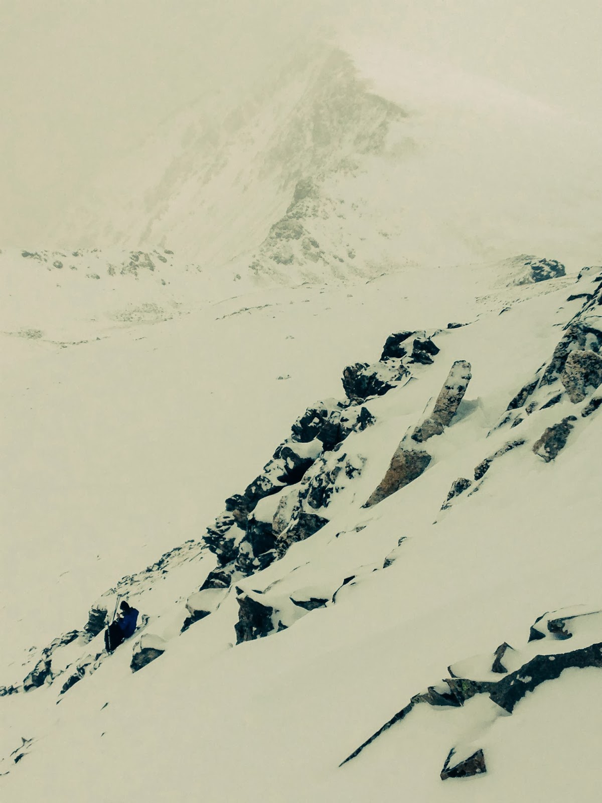
David Ponak leading the way up Grays/Torreys

My last view of the Flatirons of Boulder in a few months

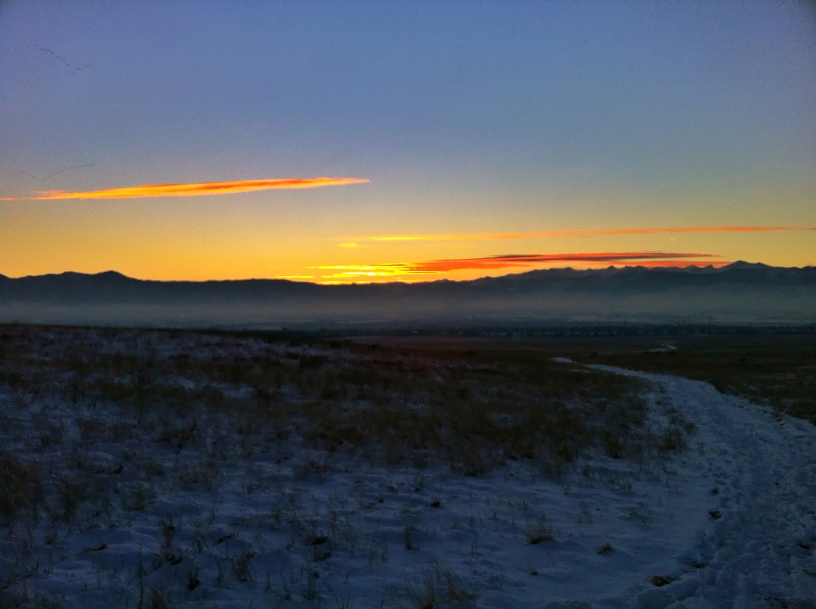
Sunset from St Sophia gondola station in Telluride

Road runs are easier with decent scenery

David Ponak leading the way in a fruitless effort up Grays/Torreys

Sunset from the St Sophia gondola station in Telluride

A nice, long road run inTelluride

My first day of work in over 16 months!

One of the many splendid views I get on a daily basis at my new "job"

Sweet inversion layer on Green Mountain in Boulder

Last run up Green Mountain before heading out to Telluride

My first run living in Telluride--a dinky one up towards Bridal Veil Falls

"Pricy" conditions are unavoidable here

Frigid temperatures making their return to Telluride
 

Tuesday, February 11, 2014

2013 14er Quest Results

During the summer/fall of 2013 I tried to summit all 75 points above 14,000' in Colorado. This included ranked 14ers as well as unranked sub-peaks. I kept this list going as a tab on my blog throughout the little project. This post is basically just moving the information from a tab to a blog post so that I may use the tab for something else. 


Ranked 14ers: 49/53
Unranked 14ers included on most lists of ranked 14ers: 5/5
Other unranked 14ers: 14/17
Total: 68/75

Total 14er Summits (Including Sub-Peaks and Repeats): 85

Date - Peak (Elevation) - Distance - Duration (h:mm) - Total Ascent
  • 5/27 - Mount Elbert (14,433') - 9 Miles - 2:53 - 4,300'
  • 5/30 - Pikes Peak (14,110') - 22 Miles - 5:31 - 7,800'
  • 6/10 - Grays Peak (14,270') - 8 Miles - 2:41 - 3,200'
  • 6/12 - Mount Elbert (14,433') - 9 Miles - 2:34 - 4,300' (REPEAT)
  • 6/13 - Belford/Oxford Combo - 10 Miles - 4:16 - 7,350'
    • Mount Belford (14,197')
    • Mount Oxford (14,153')
    • Mount Belford (14,197') (REPEAT)
  • 6/14 - Huron Peak (14,003') - 8 Miles - 2:20 - 3,400'
  • 6/15 - Grays/Torreys Combo - 10 Miles - 2:49 - 3,800'
    • Torreys Peak (14,267')
    • Grays Peak (14,270') (REPEAT)
  • 6/15 - Mount Sherman (14,036') - 3 Miles - 1:17 - 2,000'
  • 6/16 - Decalibron Group - 7 Miles - 2:29 - 3,500'
    • Mount Democrat (14,148')
    • *Mount Cameron* (14,238')
    • Mount Lincoln (14,286')
    • Mount Bross (14,172')
  • 6/19 - Wetterhorn Peak (14,015') - 8 Miles - 2:47 - 4,300'
  • 6/20 - Uncompahgre Peak (14,309') - 13 Miles - 4:16 - 4,750'
  • 7/15 - Mount Shavano (14,229') - 9 Miles - 3:37 - 4,400'
  • 7/16 - Mount Yale (14,196') - 9 Miles - 2:49 - 4,300'
  • 7/17 - Harvard Group - 14 Miles - 5:45 - 5,800'
    • Mount Harvard (14,420')
    • Mount Columbia (14,073')
  • 7/18 - Quandary Peak (14,265') - 7 Miles - 3:20 - 3,300' 
  • 7/26 - Mount Antero (14,269') - 8 Miles - 3:37 - 3,400' 
  • 7/27 - Missouri Mountain (14,067') - 10 Miles - 3:24 - 4,450' 
  • 7/29 - Mount Elbert and Sub-14er - 14 Miles - 5:00 - 5,900'
    • Mount Elbert (14,433') (REPEAT)
    • "South Elbert" (14,134')
  • 7/30 - Mount Princeton (14,197') - 13 Miles - 3:47 - 5,300'
  • 7/31 - La Plata and Sub-14er Combo - 9 Miles - 4:01 - 4,700'
    • La Plata Peak (14,336')
    • "East La Plata" (14,180')
  • 8/1 - Grays/Torreys Combo -  7 Miles - 2:54 - 3,550'
    • Torreys Peak (14,267') (REPEAT)
    • Grays Peak (14,270') (REPEAT)
  • 8/3 - Longs and Sub-14er - 11 Miles - 7:36 - 5,600'
    • Longs Peak (14,255')
    • "Southeast Longs" AKA "The Beaver" (14,060')
  • 8/4 - Evans Group - 10 Miles - 4:19 - 4,000'
    • Mount Bierstadt (14,060')
    • "West Evans" (14,256')
    • Mount Evans (14,264')
  • 8/6 - Reverse Decalibron Group and Sub-14er - 7 Miles - 2:27 - 3,750'
    • "South Bross" (14,020')
    • Mount Bross (14,172') (REPEAT)
    • Mount Lincoln (14,286') (REPEAT)
    • *Mount Cameron* (14,238') (REPEAT)
    • Mount Democrat (14,148') (REPEAT)
  • 8/8 - Redcloud/Sunshine Combo - 10 Miles - 3:20 - 4,200
    • Redcloud Peak (14,034')
    • Sunshine Peak (14,001')
  • 8/9 - Mount Sneffels (14,150') - 4 Miles - 2:02 - 2,400'
  • 8/14 - Partial Wilson Group Combo - 13 Miles - 7:58 - 5,700'
    • *El Diente* (14,159')
    • "West Wilson" (14,100')
    • Mount Wilson (14,246)
    • "South Wilson" (14,110')
  • 8/15 - Wilson Peak (14,017') -  9 Miles - 4:04 - 3,700'
  • 8/16 - Handies Peak (14,048') - 9 Miles - 2:38 - 4,600' 
  • 8/18 - Chicago Basin/Windom Group - 40 Miles - 14:45 - 11,200'
    • *North Eolus* (14,039')
    • Mount Eolus (14,084')
    • Sunlight Peak (14,059')
    • Windom Peak (14,087')
  • 8/21 - San Luis Peak (14,014') - 11 Miles - 2:39 - 3,400'
  • 8/22 - Shavano Group Combo - 10 Miles - 3:44 - 5,400'
    • Mount Shavano (14,229') (REPEAT)
    • Tabeguache Peak (14,155')
    • Mount Shavano (14,229') (REPEAT)
  • 8/23 - Mount Massive Attack - 16 Miles - 4:51 - 5,850'
    • "South Massive" (14,132')
    • Mount Massive (14,421')
    • "Massive Green" (14,300')
    • "North Massive" (14,340')
    • "Point 14,169/Hunter-Fryingpan Wilderness HP" (14,169')
  • 8/24 - Mount of the Holy Cross (14,005') - 11 Miles - 3:15 - 5,600' 
  • 8/26 - Belford Group (Nolan's 14 Pacing) - 13 Miles - 10:42 - 9,000'
    • Missouri Mountain (14,067') (REPEAT)
    • Missouri Mountain (14,067') - Re-ascent due to navigational errors - (REPEAT)
    • Mount Belford (14,197') (REPEAT)
    • Mount Oxford (14,153') (REPEAT)
  • 8/28 - Castle Group Combo - 13 Miles - 4:33 - 4,700'
    • Castle Peak (14,265')
    • *Conundrum Peak* (14,060')
  • 8/29 - Pyramid Peak (14,018') - 9 Miles - 4:42 - 4,400' 
  • 9/3 - Snowmass and Sub-14er - 9 Miles - 5:54 - 4,750'
    • Snowmass Mountain (14,092')
    • "North Snowmass" (14,020')
  • 9/5 - Capitol Peak (14,130') - 17 Miles - 6:35 - 5,300'
  • 9/6 - Maroon Peak (14,156') - 12 Miles - 6:52 - 5,550'
  • 9/7 - *North Maroon Peak* (14,014') - 9 Miles - 5:05 - 4,500'
  • 9/18 - Humboldt Peak (14,064') - 4 Miles - 2:43 - 3,200'
  • 9/20 - Kit Carson Combo - 8 Miles - 7:13 - 5,400
    • Kit Carson Peak (14,165')
    • Challenger Point (14,081')
  • 9/21 - Crestone Combo - 6.5 Miles - 7:21 - 6,250'
    • Crestone Needle (14,197')
    • Crestone Peak (14,294')
    • "East Crestone" (14,260')
  • 9/22 - Mount Lindsey and Sub-14er - 8 Miles - 5:00 - 4,750'
    • Mount Lindsey (14,042')
    • "Northwest Lindsey" (14,020')
  • 9//25 - Mount Evans (14,264') - 5 Miles - 1:50 - 1,700' (REPEAT)

Remaining (4 ranked and 3 unranked)
  • Front Range--DONE
  • Mosquito Range/Tenmile Range--DONE
  • San Juan Mountains--DONE
  • Sawatch Range--DONE
  • Elk Mountains--DONE
  • Sangre de Cristo Range (4 ranked and 3 unranked remaining)
    • "Northeast Crestone"
    • Blanca Peak
    • "Point 14,340' (Huerfano County HP)" 
    • Little Bear Peak
    • "South Little Bear"
    • Ellingwood Point
    • Culebra Point

*Peaks enclosed in asterisks are the five unranked 14ers that most people still include on lists of ranked 14ers*
"Peaks enclosed in parenthesis are unranked 14ers"

Monday, February 3, 2014

Week in Review: January 27-February 2—An Easy Week Playing in the Snow


Monday, January 27th
AM—8 Miles—2:51—2,600’—Green Mountain
I couldn’t resists getting out early and trying to be first tracks up the hill this morning. I started heading up around 6:15 or so and was pleased to discover that I was breaking trail all the way from the Chautauqua parking lot to the summit of Green. The middle route seemed to be the obvious choice since the back side would likely be an icy death trap disguised by a dusting of fresh powder. My new Saucony Goretex whatever-you-call-them’s handled great on the somewhat slick terrain and kept my feet reasonably dry in the ankle+ deep powder. I kept looking behind me worrying that Tony would come blasting by and steal my opportunity at first tracks to the summit. Fortunately, that never happened. I took the descent pretty easy and still managed to bust my ass a time or two. It’s always hard to beat the tranquility of the snow-covered mountains. 

Tuesday, January 28th
AM—9 Miles—2:29—2,800’—Green Mountain
I was up around 5AM today and debated suiting up for an early start up the hill. Instead, I waited around hoping that David would message me saying he wanted to get out for a run today. Eventually he did. So we got a late ~7:30’ish start up the frontside of Green (we still had first tracks). Conditions never really seemed that cold on the ascent, but at the summit I removed my gloves for a few minutes and my hands were frozen. We cruised at a comfortable pace down Bear Canyon through ankle-deep snow before picking up the pace a little on the Mesa Trail back to Chautauqua. I’m pretty sure we saw a trail crew out with some sort of snow removal device grooming the Mesa Trail. Must be so the trophy wives don’t’ ruin their new pair of Uggs? I think I’m starting to get a good understanding of my winter gear and layering methods. I’ve been pretty surprised at how little you really need to wear to stay warm in cold weather. 

PM—5 Miles—0:45—350’—Gunbarrel Ranch Trails
Lately it seems that all my legs want to do is move. Even when I’m physically exhausted my legs have restless tendencies. I crashed at Chris and Kari’s place out in Gunbarrel the past few nights and decided to finally utilize the nearby Open Space trails. After a mile run on roads I reached the trails and ran around for a few miles enjoying the sunset-behind-the-mountains backdrop the entire time. 

Wednesday, January 29th
AM—7 Miles—1:36—2,150’—Flagstaff Mountain and Flatirons Loop
I started up towards the NE Ridge route to Green Mountain. The climb up from Chautauqua was a chore with loads of people and some short stretches of unpacked snow. Before I reached the 1st/2nd Flatiron access trail I began overheating pretty bad. So I skipped the access trail and ran the Flatirons loop back to Chautauqua for a quick bathroom break and disposal of clothing layers. The NCAR weather station reported a temperature of 39F (yay!) with a wind chill of 7F (shit!) when I started my run. I mistakenly dressed for the wind chill rather than the absolute temperature. The problem with this was that I was rarely in the wind. I headed back up the hill with just a long-sleeve merino shirt that has some wind protection on the front and my running tights. This proved to still be too much. So, at the top of Gregory Canyon I decided to just head over to the summit of Flagstaff via Ute and back on Rangview. Then I descended Gregory again before opening up the pace a little back to the Taco. I was able to sneak in some sub-5 minute mile pace on this ~½ mile stretch. With the exception of this short burst of speed the rest of the day was slow and easy.

Thursday, January 30th
AM—9 Miles—2:23—4,200’—Green Mountain and Bear Peak
I woke up this morning with my entire body feeling pretty stiff. That can likely be attributed to sleeping the past three nights on a hardwood floor with only a sleeping bag and tiny pillow to provide some sense of comfort. So, I went to Trident to enjoy my morning coffee and give my body a chance to loosen up. Luckily, I received a call from Jeff inviting me on a trip up Green plus a little more. From Chautauqua we headed up the NE Ridge; my calves burning for a large portion of the steep ascent. Once the grade mellowed out a bit on the ridge the burning subsided and keeping up with JV was slightly less strenuous. We hit the summit of Green in around 0:52, I think. Without wasting much time, we began the descent towards Bear Canyon via the nostalgic route. Here we parted ways: JV would continue up/down Green a few more times and I would head up Bear. The climb up Bear went fairly smooth with me never really exerting too much. The merino long-sleeve shirt and mid-weight jacket I had on proved to be overkill for the day. So, I was attempting not to sweat my ass off on the climb. I topped out on the summit in 1:39, which had me hopeful of breaking 2:20 for the loop. Conditions on Fern were nearly perfect with just a few bulletproof ice patches that made me question my Microspike confidence level. Regardless, I still cruised down the snow-covered steepness at a decent pace until reaching the Mesa Trail. Here I decided to open up the pace a bit and chase that 2:20 time, but without any luck. The last climb just south of Skunk Canyon brought me to a hike before I was able to cruise back to Chautauqua for a 2:23 time on the loop. Based on how crappy my legs felt on the initial climb I’m rather pleased with how the day ended. It’s always nice to get out for a day in the mountains with Jeff, too. 

Friday, January 31st
AM—8 Miles—3:19—2,600’—Green Mountain
Broke trail all the way to the summit. The snow was always a few inches above my ankles and sometimes up to my knees. I decided to wear my nearly-knee-high OR gaiters to test them out and was a bit glad I did. It took me a little over two hours to reach the summit versus yesterday’s full loop of Green and Bear taking 2:23. On the way down I passed a few people who thanked me for breaking trail. They seemed to be enjoying it. Thoroughly exhausted afterward. 

Saturday, February 1st
AM1—5 Miles—1:16—1,050’—Mesa Trail
Met Kristen for an easy out and back on the Mesa Trail to a little below the split off for Bear Canyon. It felt nice to get out for a flat and easy run for once. My legs probably thanked me. 

AM2—2 Miles—0:17—450’—Flatirons Access Loop
After parting ways with Kristen I decided I wanted to sneak in one last climb before heading to The Sun for Stout Month. So I just did an easy jog up from Chautauqua towards the Flatirons access trails, looped around towards Mesa Trail, and jogged back down into Chautauqua. 

Sunday, February 2nd
AM—8 Miles—2:42—3,300’—Bear Peak
Headed out towards Fern from Chautauqua. Originally, I wanted to hit Bear, SoBo, Bear (again), and possibly Green if I felt up for it. Between Chautauqua and the Nebelhorn saddle I went through several iterations of my clothing layers—none of which seemed comfortable. From the trailhead I started with two layers and some liner gloves, but soon gave into the cold by putting on my third layer and I-mean-business gloves. Then I hit Fern Canyon and was starting to overheat. So back to two layers with everything unzipped and no gloves. At the saddle a fiercely cold wind presented itself causing me to put on everything I had. I was pretty comfortable from the ankles up for the rest of the day. However, my feet were soaking wet and frozen solid. I’m beginning to think the Goretex on my Saucony whatever-you-call-thems is not up to par. Sitting on the summit of Bear with frozen feet I decided to head back down Fern Canyon and call it a day. The conditions on Fern were perfect for a fun descent.


Miles—60
Time— 17 hours 44 minutes
Elevation Gain— 19,500 feet


I decided to tone things down a notch or two this week in an effort to provide my body some needed rest. Still a fun week with all the fresh snow. 

Being in South America last winter almost made me forget how much I actually enjoy getting out in the cold, snowy, and windy weather to slog up the mountains. I tend to like the misery inflicted by cold, windy weather. It really makes you feel like you earned every mile, every foot of ascent. Nothing seems to come easy when battling these conditions—and that’s why I like doing it. 

These past few weeks I’ve been acquiring new winter running/mountaineering gear and taking it out for test runs in the hills around Boulder. Through trial-and-error I’m starting to hone in on a layering system that seems to keep me adequately warm without much overheating. I admit, I still have some figuring out to do, but I’m better off now than I was a few weeks ago. 

More and more I’m becoming a firm believer that you do get what you pay for when it comes to gear. I remember my first winter running in Boulder with a bunch of cheap Wal-Mart clothes…For a run in single digit temperatures I would wear 2-3 lower body layers, 4-6 upper body layers, 3 pairs of socks, 2-3 pairs of gloves, and a hat. I could barely move with all that crap on. 

Now, in the same conditions, I get by with a single lower body layer (in addition to a pair of briefs with wind protection on the front), usually 2 upper body layers (sometimes add one more wind shell), a pair of socks, a pair of gloves, and a Buff wrap. 

Obviously, summer is still my preference. It’s hard to top being able to summit 14ers with nothing but shoes, shorts, sunglasses, and a wind shell tucked in your shorts. I think the preparation and numerous layers of clothing necessary during winter outings helps me appreciate the relative simplicity of summer ascents. 

After starting 2014 with a vicious cold it seems that I’m getting things going in the right direction. January was a pretty good month after about six weeks of relative inactivity. Here’s a comparison of January 2014 versus January 2013. This is followed by my local Boulder mountain summits for the month. 

January Totals (versus January 2013):
-Miles: 219 (versus 131)
-Hours: 63:00 (versus 54:04)
-Vertical: 72,650 feet (versus 34,600 feet)
-Vertical per Mile: 332 feet/mile (versus 264 feet/mile)

January Summits (Lifetime Summits):
-Green Mountain:15 (126 Lifetime)
-Bear Peak: 5 (22 Lifetime)
-South Boulder Peak: 1 (10 Lifetime)
-Flagstaff Mountain: 5 (134 Lifetime)
-Mount Sanitas: 1 (20 Lifetime)
-Other:1 (Horsetooth Peak near Mt Meeker)

A cold haze breaking apart to reveal the sun

Breaking trail up Green Mountain

Running through snow-covered trees

That magical part of the day when the sun illuminates the snow-dusted mountains

Heading up Green Mountain with snow still falling

Breaking trail up Green Mountain with snow over my knees in places

Remembering Patagonia with a typical Argentinean meal: milanesa, empanadas, chimichurri, and Quilmes

Enduring the cold winds heading up Bear Peak

View of Bear Peak from the Mesa Trail

Taking in the sunset with a flat run in Gunbarrel