As I staggered my way down from the summit of Capitol Peak
the hallucinations seemed more and more real. They started out simple enough in
the form of other hikers on the mountain, which I began to see well below
Capitol’s summit in the Pierre Lakes Basin. Then, I saw what appeared to be a
giant turtle—perhaps of the Teenage Mutant Ninja variety? Eventually, I made it
below treeline and saw a giant bull that looked straight out of a Texas rodeo.
Next, was a woman in a bikini at a campsite less than twenty feet off the trail
(why couldn’t this one have been real?). Most trippy of all were the detailed
faces that materialized out of splotches in the trail or in the bark on the
sides of Aspens. It’s pretty amazing what forty-plus hours (mostly) alone in
the mountains can do to a person.
I was
almost positive that I was losing my fucking mind…
It had been almost two days since I woke up in the Capitol
Creek horse trailer parking lot and prepared my gear for a second attempt at
one of the burliest routes around—a single push enchainment of the seven Elks
Range 14ers. The Elks Range is well-known for its awe-inspiring beauty, which
is probably only matched by its mostly shitty rock quality on some of the most
technical 14ers in the state. Even the more stable rock around Snowmass and
Capitol is still surrounded by shockingly unstable boulder and talus fields and
steep, loose scree slopes held in place by rock hard dirt. The recurring theme
is that everything seems to move in the Elks. All of these factors probably
have something to do with the traverse only being completed twice prior (in
1996 by Neal Beidleman and Jeff Hollenbaugh and in 2013 by Jason Antin and
Brandon Worthington).
I spent the day of August 8th (my birthday!)
preparing my food and gear for the long outing I’d begin early the next
morning. Bacon/bagel sandwiches, pretzels, dried fruit, trail mix, cookies,
gels, coconut water, Gatorade, and canned espresso drinks would be fueling me
through these 60+ miles and 25k feet of vert—in total, about 10k calories or
more. My buddy John “Homie” Prater and I had decided to link Capitol through
Pyramid together, which allowed me to pack a drop bag for his van that would be
at the Maroon Lake trailhead. My intent was to keep going from there and tag
the summits of Castle and Conundrum to complete the Elks 14ers traverse.
However, on the drive to Aspen Homie realized that he possibly wasn’t fit
enough to do the planned route. After some thinking, I decided to revert back
to my original plan of an east-to-west traverse starting from Castle Creek and
have Homie meet me at Maroon Lake with my drop bag. The route begins with the
easiest terrain and gets increasingly difficult, but allows for an up-climb of
the cruxy sections on the Maroon Bells Traverse. My primary fear going into
this traverse was downclimbing the Bells Traverse since I had only completed it
once prior.
On the morning of August 9th I woke up around 1AM
after an unexpectedly decent 2-3 hours of sleep. About thirty minutes later I
was dressed, caffeinated, and ready to roll. I hopped into Homie’s adventure
mobile and we drove to the Castle Creek trailhead. I used the drive time to
fully charge my phone (camera), down about 1,500 calories, and guzzle the
remainder of my coffee.
At 2:25AM I took off from the end of the paved road heading
up Castle Creek. The morning was pleasantly warm down low allowing me to be
comfortable in shorts, a t-shirt, and arm sleeves. When I reached the end of
the jeep road and began ascending the snow field to upper Montezuma Basin there
was a noticeable breeze and chill in the air. I used this as an opportunity to
put on my wind pants and heavy shell before cruising up the snow in
Microspikes. During my first failed attempt three days prior I found myself
wishing for Microspikes as I carefully climbed up the icy snowfield as though
it were a Flatirons slab. From the upper basin it’s a relatively painless trip
up to Castle’s Northeast Ridge, which deposits you on the summit before you
know it.
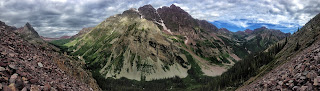
 |
| A nice view of essentially the entire Elks Traverse from Castle's summit. Taken during a scouting run. |
 |
| Conundrum from Castle's summit. Another scouting run photo. |
Without wasting much time, I began the short traverse over
to Conundrum. The talus was covered in a thin layer of frost leaving me a bit
concerned for the shitty descent down into Conundrum Valley. Exercising a bit
of caution led me to the summit of Conundrum about 26 minutes after leaving
Castle—over ten minutes slower than normal. These first two summits were cold
and windy, which motivated me to get my ass off of them as fast as possible. I
turned around almost immediately and headed to the Castle-Conundrum saddle for
my descent into the valley.
 |
| Sunrise view from Conundrum looking towards Castle. Photo taken during the Traverse. |
At 3:16 hours into the day I began my first big descent of
the route. During my first attempt I ended up staying way too far to the north
(descender’s right) and got tangled up in a bunch of cliffbands and steep,
loose gullies. Once clear of the cliffs and gullies I found myself on seemingly
endless steep, loose talus and boulders. I certainly didn’t want a repeat
performance of that descent this time. So, I made sure to swing way out to my
left (south) in an effort to avoid the cliffbands and stay on the less steep
talus/boulders. Apparently this worked because I found myself on the trail
leading to Conundrum Hot Springs in 4:58 hours versus 5:55 on my first
attempt—almost an hour difference.
 |
| Taking a dip in Conundrum Hot Springs during a scouting run. |
Once on the Conundrum Hot Springs trail I was greeted with
over 13 miles of cruiser singletrack over to the Maroon Lake trailhead. The
initial few miles were a bit chilly being in the shaded creek bed, but later on
in the day I would have traded anything for those chilly conditions. I mostly
power hiked up to Triangle Pass where I relaxed for 5-10 minutes to soak up the
sun and enjoy a bacon and ham bagel sandwich. From Triangle Pass to Maroon Lake
was a pleasant mix of trotting with short walking breaks every now-and-then.
Near Maroon Lake, I took a wrong turn on the trail that brought me out to the
main road by the West Portal trailhead. I stayed on the road and hiked up to
the lake parking lot.
 |
| Pyramid's east face. During my first attempt at the traverse (three days prior to my successful attempt) I spent almost eight hours trying to force my way up this nightmare. |
 |
| Getting a little chossy on Pyramid's east face during my first attempt. |
 |
| View of the Bells while ascending Pyramid's west face during a scouting run. |
 |
| Goats everywhere on Pyramid's west face during a scouting run. |
After 9:02 hours on my feet I was happy to sit down at
Homie’s van to refuel, resupply, and change shoes. To this point, I had been
wearing Hoka Rapa Nui’s for the easier terrain. Now, I would change into La
Sportiva Bushido’s for some stickier rubber on the more technical portion of
the route; mainly the Bells Traverse. I spent about 40 minutes at the van,
mentally preparing for the rest of the route, eating anything in sight,
guzzling Gatorade, two cans of coconut water, and two doubleshot espressos.
Homie and I discussed how realistic it would be to get off the Bells before
dark; it would be possible assuming I didn’t bonk, but difficult.
On the summit of North Maroon I was still confronted with
negative thoughts. This was basically my last logical bailout point. Descend
the standard Northeast Ridge route and I can bail back to Maroon Lake. Descend
the Northwest Ridge towards the Gunsight and I’m in it for the long haul. There
was still a shit load of tedious terrain between me and the summit of Capitol,
but the truly dangerous terrain was behind me. Which way I descended basically
just boiled down to how far I was willing to go mentally and physically—how
much exhaustion was I willing to endure?
 |
| Looking back at the summit of South Maroon from North Maroon during a scouting run. |
 |
| Looking back down at Crater Lake and Maroon Lake from North Maroon during a scouting run. |
Of course, I descended towards the Gunsight. I had already
made that decision almost twenty hours prior when I set off from the Castle
Creek trailhead. After bailing on my initial attempt a few days earlier I had
decided that any second attempt would either end successfully or with my
friends hiking in to retrieve the gear I borrowed off of my mangled body. Maybe
that’s a bit overly dramatic, but I was certainly willing to take more than the
usual amount of risks to finish this line.
The segment from North Maroon’s summit to just above
Snowmass Lake had me a bit worried. I was totally unfamiliar with the entire
portion of the route. Things started off alright with my onsight descent to the
Gunsight going much smoother than anticipated. From here, I started dropping
towards Snowmass Creek where I would begin a large contour around the basin
trying to stay around 11,600’ elevation most of the way. Homie warned me about
a cliffband below the Gunsight, which I successfully avoided. Near the creek I
spotted about 5-10 ghostly white objects that seemed to hover in the air; eyes
glowing brightly as my headlamp hit them. Frightened, I stared at these things
for a solid five minutes before realizing they were just mountain goats. Whew…
In the pitch black darkness I missed the small pass to the
south of Snowmass Lake and continued contouring around for a while. The GPS
route on my watch wasn’t working at all as it kept pointing me in the wrong
direction. Maybe I needed to recalibrate the compass? With no real idea where
the hell I was I decided to quit wasting energy wandering around lost and just
lie down. I opened the space blanket that I’ve owned for four years, yet have
never used, and curled up in the fetal position on the ground to shiver
uncontrollably for a few hours. In all, I rested about two hours, though sleep
never actually came.
When the sun finally showed I felt a renewed energy, but
that could have been the bacon and bagel sandwich I ate. I could finally see
where I was and where I needed to go. It’s hard to describe the relief one gets
when he’s lost in the mountains for several hours at night and then finally
realizes where he’s at, but it’s one of the greatest feelings in the world. Invigorated
and with a newly found sense of purpose I began making my way to the west side
of Snowmass Lake for the shittiest ascent of the day.
 |
| View of Snowmass Lake during a run of the Four Pass Loop. |
The east side of Snowmass Mountain sort of sucks, especially
if you opt to ignore the standard trail and choose a more direct line straight
to the summit. This direct line puts you on a generous helping of snow and steep,
loose scree and talus that results in the old one-step-forward- two-steps-back
progress up the mountain. Morning temperatures were quite warm, resulting in
crappy snow that I kept punching all of the way through. After a few hours of
enduring this slow progress I found myself on the summit enjoying the company
of a few guys who were the first people I had seen in fifteen hours. One of the
guys broke out a pipe and offered me a hit, which I was tempted to take. My left
Achilles had been hurting since heading up South Maroon and I wasn’t really
eating anything at this point, but one toke would probably have knocked me out
cold as tired as I was.
 |
| Near the summit of Snowmass with Capitol in the distance. Photo taken by Paul Hamilton during a scouting linkup of Capitol and Snowmass. |
 |
| View of Capitol from the summit of Snowmass during the traverse. |
The exercise in frustration continued as I descended the
loose pile of shit that is the west side of Snowmass. Rather than trying to
contour to the north on extremely loose boulders I decided to descend to where
the boulder field evens out a little bit. This allowed for some easier travel
towards my ascent of a pass just to the west of the Snowmass-Capitol ridgeline.
At this point any progress at all (up or down) seemed to take an extraordinary
amount of time and effort. From the summit of Snowmass to my crossover point on
the Snow-Cap Ridge took 2:36 hours.
I probably chose the worst route possible down and across
Pierre Lakes Basin. This was likely due to confusion/disorientation on where I
needed to go for access to the Wandering Dutchman. I wandered around confused
on where the hell I was for about an hour-and-a-half before finally getting my
bearings. During that time, I ascended a couloir that led to a route called The
Cleaver—apparently a 5.8 route that looked rather terrifying. Realizing that
this was definitely NOT the way, I retreated back down the couloir and
proceeded to have a mild panic about how I would find my way. I debated
messaging Gerber with the Delorme to see if he could tell me where to go, but
decided against it. After some thought I decided to try the GPS waypoint on my
Ambit and see if that would work. Turned out that even though the route
navigation was screwed up I was able to successfully navigate to a specific way
point.
Less than two miles from the trailhead I saw a headlamp
looking back at me. Initially, I wrote this off as another hallucination.
However, as I got closer I could hear a voice. When I finally realized that
this was a REAL person I almost lost it; it had been over 12 hours since my
last human interaction below the summit of Snowmass. Joe, the hiker, saw my
headlamp coming down the trail and decided to wait for me to have company for
the hike out. He was out taking photos of the sunset and stars and just assumed
I was another hiker out for a casual stroll. Honestly, I have never been
happier to see another person out in the mountains.
With less than a mile to go, Joe and I came across two other
hikers and chatted for a few minutes. As much as I wanted to linger and talk I
could feel my body on the verge of a complete shutdown—everything was starting
to tighten up. If I stayed there too much longer I wouldn’t even be able to
hike another step.
So, I pushed on until I finally began to recognize certain
parts of the trail. I could tell the end was near and even began to hike with a
little more pep in my step. It wasn’t much longer until Joe and I found
ourselves at the trailhead. I’m still not certain what the better feeling was:
hitting stop on my watch after 44+ hours on the move, knowing that Joe was
there to give me a ride to my truck two miles below the trailhead, or finally taking
my shoes/socks off?
It certainly wasn’t pretty or easy, but after 44+ hours of
slogging along I found myself at the Capitol Creek Trailhead with the third
known completion (fifth person to complete the route) and potentially the first
person to complete it solo.
Without a doubt, this was the hardest thing I’ve ever done…
Splits—Location—Total Time (Split from Last
Location):
Start (Castle
Creek Trailhead)—0:00
Castle Peak—2:35
Conundrum Peak—3:01 (0:26)
Castle-Conundrum Saddle—3:16 (0:15)
Conundrum Hot Springs Trail—4:58 (1:42)
Triangle Pass—5:57 (0:59)
Copper Pass—6:20 (0:23)
Maroon Lake Trailhead—9:02 (2:42)
Pyramid Peak Trail Turnoff—10:13 (1:05)
Pyramid Peak—12:42 (2:29)
Pyramid Peak Trail Turnoff—14:38 (1:56)
South Maroon Peak Trail Turnoff—15:21 (0:43)
South Maroon’s South Ridge—17:06 (1:45)
South Maroon Peak—18:02 (0:56)
North Maroon Peak—19:48 (1:46)
Gunsight—20:58 (1:10)
Snowmass Creek—21:54 (0:56)
Pass Leading to Maroon-Snowmass Trail—28:13 (6:19)
Beginning of Snowmass Ascent from Above Snowmass Lake—29:14
(1:01)
Snowmass Mountain—31:26 (2:12)
Pass Leading to West Side of Snow-Cap Ridge—33:43 (2:17)
Snow-Cap Ridge Crossover—34:02 (0:19)
Pierre Lakes Basin—34:34 (0:32)
Base of Wandering Dutchman—37:09 (2:35)
Top of Wandering Dutchman—37:33 (0:24)
K2—37:57 (0:24)
Capitol Peak—39:02 (1:05)
K2—40:08 (1:06)
Capitol-Daly Saddle—41:06 (0:58)
Finish (Capitol
Creek Trailhead)—44:10 (3:04)


Well done Kendrick! A true testament to determination and guts. Congrats on finishing this epic line!
ReplyDeleteThanks, Peter! Sorry it took me so long to respond. I'm terrible at responding to comments in a timely manner. This line was so fun I'm debating doing it in the other direction this year!
Delete