
Stats:
Time—8:32:02 (hours:minutes:seconds)
Distance—28.5 Miles
Two years ago I was in Puerto Williams to run the Dientes de
Navarino circuit at the recommendation of Peter Bakwin and Buzz Burrell. I did
a pretty long-winded write-up of that experience, which can be found here. Long
story short, it was a bit of a shit show that involved two separate attempts
and multiple times of getting extremely off-route. After the experience I had
dreamed of returning to Navarino to give the circuit a proper effort.
Well, once again I found myself in the sleepy little town of
Puerto Williams—beyond the end of the world—with intentions of running the
Dientes circuit. Fortunately, I had the GPS track from my previous debacle to
study on Google Earth and was able to compare my incorrect route with the
circuit map. I was quite surprised with how much of the route I could visualize
in my mind after two years away. After about an hour of studying the maps I
felt rather confident that I could minimize the time spent route-finding while
running the circuit.
 |
| What my shoes looked like less than half-way through my attempt in 2013 |
 |
| Map of the Dientes de Navarino Circuit with mistakes from my first attempt in 2013 written in blank ink |
My alarm went off at 4am. I was in a room by myself, which
allowed me to hit the snooze button until 5 or so before dragging my ass out of
bed. About five minutes later I was dressed and ready to go. I whipped up four
fried eggs and a cup of strong Nescafe coffee for breakfast and sat around for
a few minutes contemplating the big day ahead. A little after 6am I finally hit the road
running. The cool morning air left me wondering whether I should put on another
layer, but I decided to wait and make my final decision on wearing a jacket
once I got to Plaza de la Virgen. I made a quick detour to the police station
to let them know I was heading out (supposedly this is required), but they were
closed. So, I began the ~1.25 mile warm-up jog to Plaza de la Virgen.
At the plaza I felt plenty warm without a jacket. So, I took
off up the gentle incline of the road leading to the trailhead. After about 12
minutes I felt warmed up and ready to tackle the steeper ascent of Cerro
Bandera. There are two trails leading to the summit of Bandera: one is longer
and more gradual and the other is quite direct. I’ve found that both trails
take me about the same amount of time to reach the summit from the trailhead.
So, I chose to run the more gradual trail and enjoy a few extra miles of
running since the overall ruggedness of the Dientes Circuit doesn’t offer too
many opportunities for actual running.
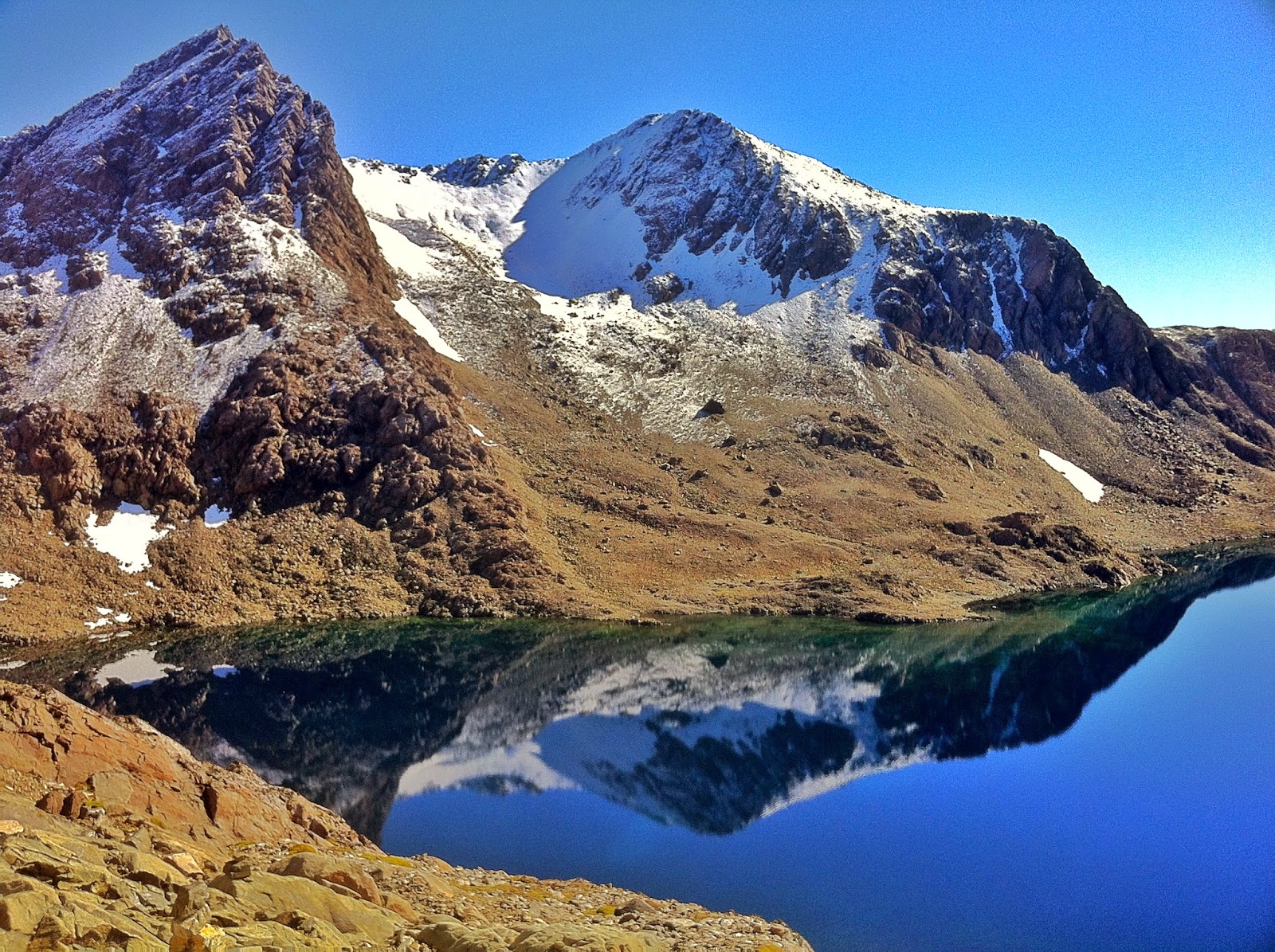
From the summit to Laguna del Salto was a gorgeous stretch
of trail in the early morning light. Here, the trail contours along the
mountainside as you head farther away from civilization and closer to the heart
of the Dientes. The increasing feeling of remoteness combined with the first
stellar views of the Dientes makes this one of my favorite parts of the circuit—plus,
it’s actually runnable! When I began the descent to Laguna del Salto I was
pleased to find the talus completely free of frost, which made the descent significantly
more pleasant than I remembered. I saw two tents on the north shore of the
laguna and this would be the only signs of civilization I would see until
reaching the main coastal road for the last few miles to close the loop.
The ascent of Paso Primero was less muddy than I remember,
but still steep and muddy enough to make for slow going. On the way up Paso
Australia I stopped to refill my UD handheld water bottle—this would be the
only time I had to refill my bottle during the day. Once I topped out on Paso
Australia and began contouring around Laguna del Paso I encountered my first
little error. There was a small snowfield to traverse, which was still solid
enough that my shoes weren’t getting any purchase. So, I dropped below and
skirted around the snowfield. This put me a little ways below the trail and had
me moving slowly on loose talus for a brief period. Eventually, I glanced up
and saw a cairn that I headed towards to get back on-trail.
From Paso de los Dientes (Marker 15) to Laguna de los
Dientes (Marker 17) went by without a problem. I wasn’t really expecting any
route-finding issues here since this was one of the few stretches of trail that
I negotiated without a problems during my last attempt at the Circuit.
One of my three major route-finding errors from my previous attempt
occurred while skirting around the north shores of Laguna de los Dientes. In 2013,
I lost all signs of the route and made a decision to ascend a low point in the
ridge to the north of Cerro Gabriel before dropping down the other side. Looking
back I realize how incredibly stupid this was, but sometimes you just make bad
decisions when trying to do long, challenging routes in short amounts of time. Fortunately,
this time around I was able to stay on the route and make it to Marker 20 on
the south shore of Laguna Escondida without a problem. Somewhere near Marker 21
I headed slightly off-route to the north towards what I thought was Paso
Ventarron. It seemed like a lot of cairns were haphazardly placed around here
making it a bit easy to veer off-route. Luckily, this little mistake only cost
me about 5-10 minutes.
After topping out on Paso Ventarron the wind picked up for
most of my descent. It wasn’t terrible wind, but it was pretty cold. This was
one of two or three times that I debated putting on my jacket, but I fought the
urge and kept on moving. I spent a few minutes at Paso Ventarron eating my
chocolate bar, which would be the only calories I consumed all day.
At the base of the short ascent of Paso Guerrico was where
my second big route-finding error occurred in my previous attempt. Here, I lost
the route and made my way up a steep, sketchy slope that was a mix of snow and
scree. When I reached the ridge I could see Laguna Martillo on the other side
and negotiated a shit show of a descent down to its shore as head-sized rocks
tumbled down all around me—ugh. Once again, my studying of the route allowed me
to avoid this costly error and I made it from Paso Ventarron to Laguna Martillo
without a problem.
The stretch from Laguna Hermosa to above treeline on the
ascent of Paso Virginia is probably the muddiest stretch of trail for the entire
circuit. One benefit of doing the circuit in a day is that you just don’t care
how wet and muddy your shoes get. This makes the muddy, boggy sections significantly
easier. From Marker 31 to 32 there are some steep-as-hell sections with “steps”
cut into the mud, which required a lot of pulling on trees just to get up the
crap. I wouldn’t envy anyone doing this with a heavy backpack…
 |
| I started/stopped my watch for the circuit at this street sign |
 |
| Reaching the summit of Cerro Bandera on a beautiful, crisp morning |
 |
| Heading up Cerro Bandera |
 |
| Contouring towards Laguna del Salto |
 |
| View near Paso Australia (Photo from my 2013 attempt) |
 |
| Photo from Paso Austrailia |
 |
| View from Paso de los Dientes |
 |
| I actually took the correct route this time. The route skirts along the left side of Cerro Gabriel and is pretty flat and easy |
 |
| In 2013, I made a huge route-finding error and decided to go up-and-over the ridge to the right (north) of Cerro Gabriel. I was treated to this shit show of a descent down to Laguna Escondida. |
 |
| Heading west after Paso Ventarron |
 |
| Looking to the south towards Cape Horn from Paso Ventarron |
 |
| Laguna Martillo |
Around Marker 33 you reach a huge, flat’ish rocky area that
seems to go on forever before finally reaching Paso Virginia. My legs were
finally starting to feel the fatigue of the day and I proceeded to walk most of
the way to the pass. The descent from the pass to Laguna Guanacos is probably
my favorite part of the entire circuit. Here, you’re treated to a steep,
straight-line descent on the most perfect scree you can imagine. In no time I
found myself on the south shore of the laguna and trotting along its west side.
After Marker 36 the route becomes increasingly harder to
follow. First, a few boggy areas must be crossed. Then, it just short of turns
into a choose-your-own-adventure slog back to the coastal road. I was able to
stay on-route fairly well, surprisingly. Somehow I managed to find Marker 37,
which the people at the tourist information office say no one ever finds.
Marker 38 was too elusive for me, though. When making my way back to the road I
opted to stay slightly above the stream running from Laguna Guanacas to the
road versus making the typical mistake of traveling alongside the stream. This
seemed to be the correct route as I kept seeing the red-paint trail markings on
trees every now-and-then. The amount of downed trees in this area have led to
people (and animals) taking every possible combination of routes to get to the
road, which leads to many well-beaten paths taking off in all directions—none of
them really the “correct” path.
 |
| View of the Beagle Channel from Paso Virginia |
 |
| Looking back up at the scree descent from Paso Virginia (Photo from 2013) |
Once I got out of the woods and into the cow/horse pastures
I spotted the ex-pesquera MaClean (old fish factory) down near the Beagle
Canal. This is the target you want to pursue when trying to get back down to
the road. Again, there are countless paths in all directions, but most of them
dead end at huge areas of Calafate bushes (these are like rose bushes, but with
little berries instead of flowers). I basically had two choices for negotiating
this terrain: avoid the bushes and take forever to get down or run in a
straight line through the bushes and make the descent quicker. I opted to run
straight through the goddamn things and reached the road in pretty good time—7:57
total time. My legs looked like they were in the middle of a cat fight…
Now, the only thing between me and a warm shower was ~4
miles of hilly gravel road. This stretch proved to be more difficult than
expected. My legs were tired from eight hours of travel, but they were still
quite capable of running quickly since I hadn’t really done much running all
day. So, this stretch was more mental than anything—making my legs run at a
quicker pace when all they really wanted to do was walk. After about 35 minutes
I finally caught glimpse of the Plaza de la Virgen and street sign on the
corner where I started my watch over 8.5 hours ago. When I reached the street
sign and hit stop my watch read 8:32:02—a new FKT by almost 3 hours.
Some Thoughts:
 |
| Getting closer to the Beagle and the coastal road. Near Marker 37, sort of... |
 |
| Finally done after 8.5 hours... |
 |
| My scratched up legs after running through calafate bushes. They were worse than they look in the photo... |
- After doing this route a few times I feel that I could probably give it another solid effort and take an hour or so off the time. Even though I knew the route significantly better this time I was still running the entire day with the map in my hand and glancing down at it every 5-10 minutes.
- The route markings are WAY better than two years ago
- The circuit seemed much more adventurous the first time without any knowledge of the route
- If someone wants an adventure they should go run the route without a GPS track. If someone wants an FKT they can easily run much faster than what I did by taking my GPS track off Strava or something.
- This circuit is still rugged, remote, and awesome. I didn’t see a single other person the entire day!
Splits:
Location—Split Time (hr:min:sec)—Total Time
Start at Plaza de la Virgen—0:00:00—0:00:00
Trailhead—0:12:24—0:12:24
Cerro Bandera Summit—0:34:02—0:46:26
Marker 12: South Shore of Laguna del Salto—0:55:04—1:41:30
Paso Primero—0:06:23—1:47:53
Paso Australia—0:16:52—2:04:45
Paso de los Dientes—0:14:22—2:19:07
Marker 17: Laguna de los Dientes—0:25:44—2:44:51
Paso Ventarron—1:05:00—3:49:51
Paso Guerrico—0:38:58—4:28:49
Paso Virginia—2:07:12—6:36:01
Marker 35: Laguna Guanacos NE Shore—0:23:06—6:59:07
Coastal Road Near Ex-Pesquera Maclean—0:58:10—7:57:17
Finish at Plaza de la Virgen —0:34:45—8:32:02 (New FKT)
Gear List:
Wearing:
Salomon Fell Raisers
Smartwool anklet socks
Brooks windproof briefs
Brooks running shorts
Helly Hanson t-shirt from Power of 4 race in Aspen
Pearl Izumi arm sleeves
Marmot wind/water resistant gloves
Buff wrap
Ultimate Direction handheld water bottle
Suunto Ambit
Osprey Rev 6 Backpack:
iPhone 5 (for photos)
Map of route
GoLite puffy jacket
Mountain Hardware wind/water proof jacket
Marmot wind/water proof pants
Pocketknife
Lighter
Emergency blanket
Ham/cheese sandwich (didn’t eat)
Chocolate bar (ate all of it)