
Week in Review: May
11-17
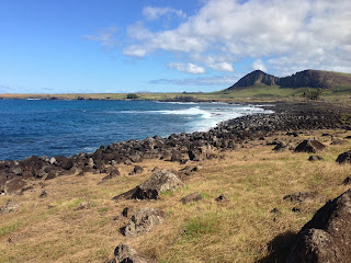
Monday, May 11th
AM—38
Miles—8:40—4,900’—Easter Island Circumnavigation
After talking to a few locals I found out about a faint
trail that circumnavigates the entire island. Naturally, I decided that a
run/hike of this trail would be a great way to scope out the area. Most of the
route can be seen by renting a car/bike since the paved roads are never really
that far from the coast. The notable exceptions are the northwest portion of
the island (from Hanga Roa to Anakena Beach) and the Poike peninsula.
The daytime high was to be around 76F, which sounded miserably
hot to me after four months of wearing a down jacket in the extreme southern
reaches of Patagonia. With the total absence of water along the route, I opted
to wear my Osprey Rev 18 pack to utilize its 3-liter water bladder and bring
along some calories.
I hit the road from Camping Mihinoa around daybreak to avoid
the need for carrying a light. About fifteen minutes into the day I was already
sweating my ass off. The stretch from town to Anakena was gorgeous, but
tedious. The path is a horse trail (at best) and is constantly littered with
fist-to-head-sized lava rocks. So, one must be mindful of essentially every
single step. At one point I came across a gaucho herding some cattle and had
some fun racing alongside him on his horse.
After 2:40 I found myself running along the white sand of
Anakena Beach and fighting the urge to strip down and jump in. I kept trucking
along and about twelve minutes later found myself descending to Ovaja Beach—a
glorious semi-hidden gem. From Anakena to the north side of Poike peninsula was
noticeably more technical than the previous stretch of path, but once I reached
Poike the lava rocks disappeared to yield some pleasant running. On the north
coast of Poike is a high point (one of two or three little bumps north of the
Poike volcano) that I could have skirted around, but opted to go up-and-over
instead.
Circling around the peninsula seemed to take forever. The
heat and constant exposure to the strong sun were beginning to take their toll
on me. I had been fiercely rationing my water all day, but still felt as though
my supply was nearing its end. So, on the south side of Poike I stopped for a
few minutes to get some applesauce packets out of my pack and check on the
level in my bladder. To my surprise, I still had a little over 2.5L remaining. One
benefit of my minimal approach regarding the use of food/water in my daily
running is that I can get pretty damn good miles per gallon of water…
Eventually, I reached the southern end of the Poike
peninsula and was faced with a choice: drop down a steep, grassy/rocky slope to
the beach just east of Tongariki or add on extra distance to take a more
round-about (but safer) way down. I decided to just drop straight down the
slope. The view from the top of the slope was rather intimidating. I still had
15’ish miles separating me from the town and could see Rano Kao WAY off in the
distance. Ugh…
By the time I reached Tongariki I was somewhere around a
marathon in distance and feeling pretty spent. My legs still had some pep, but
it was just way hotter than I anticipated. I tried sticking to the trail on the
coast for a mile or so, but it was even worse than the north side of the
island. So, I stuck mainly to the road back to Hanga Roa. The major downside to traveling along the road
was the heat coming from the pavement. I could run along at 10-11 minute pace
for about ten minutes before I felt like I was overheating and would stop to
walk in an attempt to cool down. When I finally neared the volcano of Rano Kao
I decided to skip it and just head straight back to town. I already ran up Rano
Kao a few days prior.
I would love to come back some day and run this with proper
heat acclimation. I would definitely start significantly earlier and try to
cover about half of the miles before sunrise.


Tuesday, May 12th
AM—32 Miles—3:00—1,750’—Easter
Island Road Cycling
My legs were still a bit sore after yesterday’s run around
the island. So, I decided to rent a bike and tour the island. I set out on the
bike today with two goals: never have to walk the bike and never have to go
into the lowest gear. I met both of the goals. After about 20km I stopped at
the beach one last time for about three hours of sunworshipping and playing in
the ocean. After drying off a bit I took off to complete the loop around the
island.
Wednesday, May 13th
OFF—Just enjoyed my
last day in Easter Island and returned to Santiago
Thursday, May 14th
AM—10
Miles—1:16—500’—Santiago Roads
I had several errands to run today. So, I decided to
literally run them. I set out from my hostel at Plaza de Armas and ran to a
store where they could fix the band on my Suunto Ambit. My band basically just
fell apart after three years of heavy duty wear-and-tear, which left me piecing
it together with whatever I could find. First, I used duct tape. Then, when
that quit working I used a fancy purple ribbon, which lasted for all of the
Dientes de Navarino Circuit. Eventually, I settled on using zip ties. The
obvious problem with most of these fixes was that I could never remove the
watch. After getting my watch fixed I stopped by Outsoul (a running store that
has Ultimate Direction, Kahtoola, and various other products from The States)
to chat with the owners about getting out for a run up one of the local peaks.
From there, I just took the Metro back to my hostel since the streets were too
busy for any enjoyable running.
Friday, May 15th
OFF—Still taking
several off days per week as I pump up the volume slowly
Saturday, May 16th
AM—20 Miles—4:35—6,700’—San
Cristobal (x2), Cerro Manquehue, Cerro El Carbon
I hit the roads at 8:45am from my hostel at Plaza de Armas
with intentions of meeting Max for some miles around San Cristobal. I think we
were both waiting on the other person in different places since we ended up
never seeing each other. After two trips up-and-down San Cristobal yelling
Max’s name I finally gave up and started making my way towards Cerro Manquehue.
When I finally started ascending the trail heading up these peaks I had already
covered eight miles and 1,400’ of vert. The ascent was HOT. I don’t know if 75
degrees has ever felt as hot as it does here. I stuck to the Southwest Ridge (I
think?) for both my ascent and descent. This route offers up a few short
stretches of 3rd Class terrain and also avoids people on the 1st
Class trails leading to the summit. With about 15 minutes of loitering on the
summit under my belt I took off towards Cerro El Carbon and a little less than
thirty minutes later was standing on the summit with a bunch of Boy Scouts or
something. I downed the rest of my water on the summit and began the horrible
descent. These trails are all nothing but bald dirt, which leads to a lot of
slipping-and-sliding while descending. Once I reached the bottom I stopped at a
kiosko for a drink and some plums. The old lady who runs this place gave me a
bunch of water and three apples for free about a week ago when I was bonking
hard from the heat. She seems to think I’m crazy for running around in the
mountains. After my little break I hit the pavement for a bit of the way back
up San Cristobal before veering onto a nice contouring trail. Once I made it
back down to Bellavista I decided to just walk back to Plaza de Armas due to
the hordes of people on the sidewalks. Not a bad morning at all…
Sunday, May 17th
OFF—Resting up to hit
the trails running tomorrow
Weekly Totals
Miles—68
Time—14 hours 33 minutes
Elevation Gain—12,100
feet
Week in Review:
May 18-24
Monday, May 18th
AM—11
Miles—2:08—2,800’—San Cristobal Hill Repeats (x4)
I wanted to get in a decent amount of vertical today, but
without the 18-22 mile commitment of El Carbon or Manquehue. So, I just decided
on repeats of San Cristobal. The ascent is about 0.7 miles and gains 600-700
vertical feet—100% runnable. My first lap came in just under fourteen minutes.
Then, I turned around and used the descent as a recovery. I proceeded to do
three more laps this way with each being faster. The last ascent was right at
thirteen minutes. I decided to call it quits here since I have plans to ascend
Cerro Provincia on Wednesday with friends and want a little energy in my legs.
Tuesday, May 19th
OFF—Decided to rest a
day before heading up Cerro Provincia
Wednesday, May 20th
AM—12
Miles—3:37—6,300’—Cerro Provincia
I left the hostel early to get on a packed Metro car to my
meeting point with Renzo and Katherine. The slight drizzle had me a bit
concerned with what the weather would be like up high even though the Mountain
Forecast site said it would be sunny and perfect. The route begins with a nice
rocky section before pretty much just heading straight up to Alta de Naranja. A
lot of vertical is gained here. Less than fifteen minutes into the day and I
was stripped down to skimpy shorts and nothing else—it was damn hot. To my amazement,
Renzo and Katherine were in tights and long sleeves the entire day. I’m almost
positive if I tried wearing that it would have been the end of me. After we
reached Alta de Naranja we had a few kilometers of rolling hills that offered
some much welcomed runnable terrain. Eventually, the steepness picked back up
and we found ourselves power hiking up to the false summit before really being
able to run again. Occasionally, I would let a gap develop between us just so I
could run to catch up. Just beneath the false summit is a short stretch of 3rd
Class terrain that breaks the monotony of just power hiking up to the summit. As
usual per trails in Santiago, the descent can be a death trap. It hasn’t rained
in this area for seven months. So, you can imagine how dry and hard the trails
are. My footwork felt spot on, but some annoying pain in my left shin caused me
to slow down a bit on the descent. During the rocky, technical sections I would
fly through them, but then slow way down on the hard dirt. Before too long we
found ourselves back down at the car. This was a great route and even better
company. Renzo was charging up the mountain really well and Katherine was
flying down the mountain pretty damn fast. Great day out!
Thursday, May 21st
AM—18 Miles—3:32—4,900’—Cerro
El Carbon
With Max Keith. Max and I tried to run together last
Saturday, but we couldn’t find each on the trails. So, this time we made sure
that we had a good meeting point. I ran the 4-5 miles to our meeting point
really easy since my legs were a bit tired from yesterday. It was a struggle to
get below 9-minute pace those first few miles. Fortunately, Max seemed OK with
taking a casual approach to the day. We ran a short stretch of road/trail
before getting to the trail up El Carbon. Here, I was happy to see Max fall
into a power hike—my legs were too tired. We took a rather direct line up the
mountain that avoided all of the switchbacks. As we neared the saddle between
El Carbon and Manquehue we began running a little more and proceeded to run
most of the way up to the summit from the saddle. The perfect weather on the
summit enticed us to linger around for 15-20 minutes before trotting back down.
At the end of the run I showed Max the route I used to ascend/descend San
Cristobal since he has never really used it. Hope to share more miles
(kilometers?) with Max when I get back from Mendoza.
Friday, May 22nd
OFF—Travel to Mendoza
to renew my Chilean tourist visa
Saturday, May 23rd
AM—3
Miles—0:25—100’—Mendoza Roads
Decided to head out for a little road run. After a handful
of near-misses with getting run over by cars I decided to go back to the house
and call it a day.
Sunday, May 24th
OFF—Just sat in bed
all day watching movies. Wish Mendoza were closer to some mountains.
Weekly Totals
Miles—44
Time—9 hours 43
minutes
Elevation Gain—14,100
feet
Week in Review:
May 25-31
Monday, May 25th
OFF—Not really
feeling motivated to run in Mendoza. Just using this as some rest days.
Tuesday, May 26th
AM—17 Miles—2:50—1,400’—Mendoza
Roads and Foothills
I was planning to just do a mellow run on roads and around
the park. When I reached the west end of the park I found some dirt roads
heading up a small hill and made my way up. From the top of the hill I could
see off in the distance and spotted a few trails meandering out into the
foothills. So, I made my way to these and quickly found myself on a nice ridge
connecting several bumps along the way. Eventually, the absence of water and
the presence of extremely brown’ish urine made me turn around and start making
my way back.
Wednesday, May 27th
OFF—Long day on the bus
back to Santiago. Chilean border patrol was on strike. So, it took us 4.5 hours
to cross. When I got back to Santiago I was too exhausted to run.
Thursday, May 28th
OFF—Kind of a nasty looking
day in Santiago. Didn’t do much of anything.
Friday, May 29th
AM—26
Miles—6:11—7,000’—Cerro El Carbon, Cerro Manquehue, Cerron El Penon, Cerro
Montegordo, Cerro La Region, and San Cristobal
When Max and I ran El Carbon last week he pointed out a linkup
of several summits in the area. So, I took his recommendation and decided to do
that today. I took the Metro to Escuela Militar to avoid the usual eight miles
of running just to get to La Piramide. This cut the approach run to about three
miles on roads through the city before beginning the ascent of El Carbon. I
hiked most of the ascent and reached the summit in 51 minutes. Next, I made my
way up Manquehue via its more direct southwest ridge and enjoyed a little 3rd
Class terrain. On the way to El Penon I got on the wrong trail and started
descending, but after a little off-trail meandering I found myself on the
correct path. While ascending El Penon the views looking back on Manquehue were
pretty stunning. At the summit of El Penon I made a pretty big mistake that
cost me ~15 minutes. I didn’t have a very good view of the ridge from the
summit and somehow ended up descending a pretty awful, steep slope towards some
little bump of a mountain between Montegordo and El Carbon. After some
bushwhacking (lots of cuts and blood from this one) I was able to contour
around and catch a glimpse of the correct path. Eventually, I made my way there
and was treated to a nice stretch of cruiser trails to the summit of Montegordo.
The ascent of La Region was the last big climb of the linkup, but passed by
rather quickly. Once on the summit of La Region the real shit show began. The
descent began innocently enough with some steep, loose trails and eventually
transitioned into a dirt road. Somehow, I got off the road and started going
straight down the hill on horrendously dry, loose, steep terrain before
reaching some cow trails that contoured around below the highway. After several
miles of cow trails I found myself in a slummy area that reminded me of
Brazilian favela scenes in movies. While running through these areas I trotted
along slowly in an effort to save some energy for an all-out sprint should the
need arise. I just kept moving while avoiding eye contact with all of the
people giving me the
what-the-hell-is-this-Gringo-in-short-shorts-doing-running-here look. Soon
enough, the buildings started looking a little nicer and I found myself in a
rather rich-looking part of town on the north side of La Piramide. Once in a
comfortable feeling area I consulted the map on my iPhone and realized that
getting back to La Piramide wasn’t going to be easy at all. So, I ran by a huge
cemetery, crossed a major highway, and finally found myself at one of the paved
roads up the north side of San Cristobal from Los Turistas. Overwhelmed with
relief I made my way up the hill. Somehow my legs felt pretty good, which led
to me giving this ascent a reasonable effort. I knocked out the3.6 miles and
1,000 feet in just under 34 minutes before casually descending and trotting
back to Plaza de Armas. Whew…
Splits:
Start—Escuela Militar Metro Station—0:00:00
La Piramide—20:20 total
El Carbon—1:11:46 total (51:26 from La Piramide)
Manquehue—1:50:42 total (38:56 from El Carbon)
El Penon—2:22:05 total (31:23 from Manquehue)
Montegordo—2:59:33 total (37:28 from Penon)
La Region—3:28:27 total (28:54 from Montegordo)
Favela Neighborhood Roads—4:11:16 total (42:49 from La
Region)
La Piramide to Favela
(Trail Section)—3:50:56
Saturday, May 30th
AM—10 Miles—2:04—3,400’—Salto
de Apoquindo
Great run with Renzo, Katherine, and another friend of
theirs. My legs were noticeably tired after yesterday’s run, but overall I felt
pretty decent during the outing. The waterfall is a nice, hidden gem of
Santiago and is surrounded by some rather gorgeous scenery. On the way back we
had a little fun on some of the descent trails and picked up the pace a little.
Maybe 6:30’ish minutes/mile? Not terribly fast, but fast enough considering how
easy it is to lose control on the super dry trails.
Sunday, May 31st
OFF—BBQ at Renzo’s
Weekly Totals
Miles—53
Time—11 hours 6
minutes
Elevation Gain—11,800
feet


